Impressions of Washington: “An overgrown, tattered village”
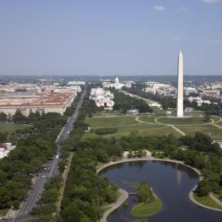
Not surprisingly, our nation’s capital has undergone some pretty radical changes since its beginning. One hundred and sixty years ago, the landscape of the National Mall and surrounding streets looked vastly different than it does today. We’re talking an armory, one museum, the Washington Monument, and not much else.
Speaking to the Historical Society in 1901, Presbyterian minister and Chaplain of the Senate Byron Sunderland described the Washington he remembered in the mid-19th century.
“At that time, it seemed like an overgrown, tattered village which some late hurricane had scattered along the river’s edge. Many of the old landmarks had been swept away; great changes had come over the site of the town. The plan of the city approved by Washington, whose great name it was to bear, had been chiefly laid out and the city proper lay within the limits of the boundary line [now Florida Avenue], Rock Creek, the Potomac, and its Eastern Branch. The two principle centers were the White House and the Capitol.”
“The Mall and the White Lot, lying much as they do to-day — disfigured then by no railroad tracks, but much more so by the nauseous canal — was then, as since, the scene of many a gathering and parade and pleasant drive, covered in many parts by stately forest trees and various undergrowths with intervening lawns and meadow lands with footpaths and carriage-ways running from the botanical gardens and conservatories down to the government pools by the river’s brink.”
“As I remember it in 1852-5 only three structures had been reared upon it: The government armory, where it stands to-day; the Smithsonian Institution, then recently completed... and the Washington Monument, then simply a huge stone stump about two hundred feet high...”


“Along the north side of the Mall, from Sixth to Fourteenth Streets, were numerous lumber yards, sawmills, planning mills, brass and iron foundries and coal yards, and between these and the avenue extending from Seventh to Ninth Streets the Center Market, which since that time has undergone great changes.”[1]
Today, the area north of the Mall between 6th and 14th streets holds the Federal Triangle and Archives metro stops. The old lumber yards and sawmills have been long replaced by the National Archives, Department of Justice, Internal Revenue Service, and Environmental Protection Agency. In the exact spot where the National Archives sit today, between 7th and 9th streets, the bustling Center Market once stood.
“The centers of attraction of visitors of course were the White House, then without its conservatory, the Capitol with its Library, the Navy Yard, the Treasury, the National Museum, the Dead Letter Office, and the Smithsonian.”
Well, there was another “attraction” for a certain breed of visitor. ... Just between the current Air and Space Museum and Museum of the American Indian once stood “the notorious Mary Hall house,”[2] known to be a famous brothel run by prostitute Mary Ann Hall.
It’s a sharp contrast to today’s landscape, no doubt. But Sunderland also thought that “some day perhaps it may be surrounded by another structure in memory of the famous dead of the nation.”[3] He was definitely right on that one.
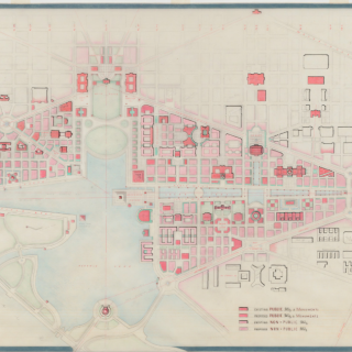
A larger version of the 1850s map can be seen here.
![Sketch of the mythical fuan by Pearson Scott Foresman. [Source: Wikipedia]](/sites/default/files/styles/crop_320x320/public/2023-10/Goatman_Wikipedia_Faun_2_%28PSF%29.png?h=64a074ff&itok=C9Qh-PE1)
")
")
")
")
")